

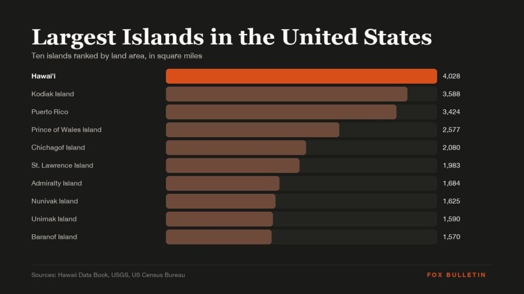
The largest island in the United States is Hawaiʻi, the Big Island, at 4,028 square miles of land. It is bigger than the other seven Hawaiian islands put together, and Hawaii County, which covers it, accounts for 62.7 percent of the state’s land area, the highest share of any county in the country.
Below it the list belongs almost entirely to Alaska. Seven of the ten largest islands in the United States sit off the Alaskan coast, most of them in the Alexander Archipelago of the southeast panhandle, and the only other entry is the main island of Puerto Rico. Areas are land area; populations are from the 2020 Census.
| Rank | Island | State or territory | Area (sq mi) | Area (km2) | Population (2020) |
|---|---|---|---|---|---|
| 1 | Hawaiʻi (Big Island) | Hawaii | 4,028 | 10,433 | 200,629 |
| 2 | Kodiak Island | Alaska | 3,588 | 9,293 | 12,932 |
| 3 | Puerto Rico (main island) | Puerto Rico | 3,424 | 8,868 | 3,275,833 |
| 4 | Prince of Wales Island | Alaska | 2,577 | 6,675 | 5,559 |
| 5 | Chichagof Island | Alaska | 2,080 | 5,388 | 1,342 |
| 6 | St. Lawrence Island | Alaska | 1,983 | 5,135 | 1,352 |
| 7 | Admiralty Island | Alaska | 1,684 | 4,362 | 650 |
| 8 | Nunivak Island | Alaska | 1,625 | 4,209 | 191 |
| 9 | Unimak Island | Alaska | 1,590 | 4,119 | 35 |
| 10 | Baranof Island | Alaska | 1,570 | 4,065 | 8,532 |
The 10 Largest Islands in the United States Ranked
1. Hawaiʻi, the Big Island: 4,028 Square Miles
State: Hawaii | Highest point: Mauna Kea, 13,803 feet | Population: 200,629
The Big Island is the youngest of the Hawaiian chain and still growing, because Kīlauea and Mauna Loa keep adding lava to its southern coast. Its 4,028 square miles hold eight of the world’s thirteen climate zones, from tropical rainforest on the Hilo side to alpine desert near the Mauna Kea summit, where the observatories sit above the cloud layer.
Despite its size the island holds only about 14 percent of Hawaii’s population. Oʻahu, which is a quarter of the area, has nearly a million residents.
2. Kodiak Island: 3,588 Square Miles
State: Alaska | Coastline: About 1,343 miles | Population: 12,932
Kodiak is the second largest island in the country and the 80th largest in the world, slightly bigger than Cyprus. Its deeply indented coast is why the ranking is sometimes disputed: in 2010 Sarah Palin called it America’s largest island, and the Anchorage Daily News worked out that the claim holds only by shoreline, where Kodiak’s 1,343 miles dwarf the Big Island’s 266. By land area Hawaiʻi wins comfortably.
Even Kodiak’s area depends on who measures it: 3,588 square miles in most references, 3,595 by Alaska’s Division of Mining, and over 4,900 if the surrounding islets are folded in. The island is home to the Kodiak brown bear, the largest subspecies of brown bear.
3. Puerto Rico: 3,424 Square Miles
Status: US territory | Population: 3,275,833 | Note: Most populous US island
Puerto Rico’s main island is the only entry in the top ten outside Alaska and Hawaii, and by a wide margin the most populated: more people live on it than on the other nine islands combined many times over. The Census Bureau gives the territory 3,424 square miles of land, a figure that also includes the smaller islands of Vieques, Culebra and Mona, so the main island alone is fractionally smaller. It stays third under any of the published figures.
4. Prince of Wales Island: 2,577 Square Miles
State: Alaska | Region: Alexander Archipelago | Population: 5,559
The largest island in the Alexander Archipelago is also the most road-connected, with a network built for logging in the Tongass National Forest. Its area comes from a US Geological Survey field map of the region, the same source used for Baranof at number ten. The island’s karst limestone holds some of the deepest caves in the country.
5. Chichagof Island: 2,080 Square Miles
State: Alaska | Region: Alexander Archipelago | Population: 1,342
Chichagof has one of the densest brown bear populations anywhere. Most of the island is wilderness within the Tongass, with the small communities of Hoonah, Pelican and Tenakee Springs on its coast.
6. St. Lawrence Island: 1,983 Square Miles
State: Alaska | Location: Bering Sea | Population: 1,352
St. Lawrence sits closer to Russia than to mainland Alaska, about 36 miles from the Chukchi Peninsula. Its two villages, Gambell and Savoonga, are Siberian Yupik communities, and the two village corporations hold title to the island itself, more than a million acres, after opting out of the 1971 Alaska Native Claims Settlement Act.
7. Admiralty Island: 1,684 Square Miles
State: Alaska | Region: Alexander Archipelago | Population: 650
Almost all of Admiralty is a national monument and designated wilderness. Its Tlingit name, Kootznoowoo, means fortress of the bears, and Forest Service estimates put the population at roughly 1,600, more than one per square mile and about three bears for every resident. The one settlement is Angoon.
8. Nunivak Island: 1,625 Square Miles
State: Alaska | Location: Bering Sea | Population: 191
Nunivak is a volcanic island of tundra and lakes with a single village, Mekoryuk. It is best known for the musk oxen introduced in the 1930s after the species had been hunted out of Alaska, a herd that later seeded reintroductions on the mainland.
9. Unimak Island: 1,590 Square Miles
State: Alaska | Chain: Aleutian Islands | Population: 35
The largest of the Aleutians is dominated by Mount Shishaldin, a near-perfect volcanic cone that is among the most active in the chain. Unimak marks the boundary between the Bering Sea and the North Pacific and has fewer than forty residents.
10. Baranof Island: 1,570 Square Miles
State: Alaska | Main town: Sitka | Population: 8,532
Baranof holds Sitka, the old capital of Russian America and the second most populous place on this list after Puerto Rico. The island is steep and glaciated, with peaks above 5,000 feet rising straight from the sea, which is why nearly everyone lives on the coast around Sitka.
Where Long Island Ranks
Long Island, at 1,401 square miles, misses the top ten by less than 170 square miles and sits eleventh. It is the largest island in the contiguous 48 states and, with more than eight million residents across Brooklyn, Queens, Nassau and Suffolk, the most populous island in any US state or territory. Puerto Rico’s main island, though larger, is a territory rather than a state.
The next two after Long Island are also Alaskan: Revillagigedo at 1,145 square miles, which holds Ketchikan, and Kupreanof at 1,086. Alaska therefore accounts for nine of the top thirteen.
Why Alaska Holds Seven of the Ten
The Alexander Archipelago alone contributes four entries: Prince of Wales, Chichagof, Admiralty and Baranof. These are the tops of a drowned mountain range, the same coastal ranges that continue south into British Columbia, separated from the mainland by fjords cut during the last ice age. Two more, St. Lawrence and Nunivak, are the remnants of the Bering land bridge, and Unimak is the first link in the volcanic Aleutian arc.
Hawaii’s islands are volcanic hotspot islands instead, which is why the Big Island, the youngest and most active, is also the largest: it has had the least time to erode. Puerto Rico is continental crust of the Greater Antilles. Three different geologies produce the three regions on the list, and the Great Lakes, for all their size, contain nothing bigger than Isle Royale at 206 square miles.
Reading the Area Figures
Island areas are less settled than they look. The Hawaii figure comes from the state’s own data book, the Alaskan figures from the USGS and the Britannica, and Puerto Rico’s from the Census Bureau. Different agencies draw the shoreline at different tide lines and treat inlets and connected islets differently, which is enough to move an island by a few dozen square miles and to produce four competing numbers for Kodiak.
None of those disputes changes the order of the top ten, and the gap between tenth place and Long Island is wide enough that the cut-off is safe too. For a similar look at how the record books are kept in another field, see our ranking of the most goals in football history, where the counting method changes the podium, or the oldest countries in the world, where the definition decides everything.
Frequently Asked Questions
What is the largest island in the United States?
Hawaiʻi, known as the Big Island, at 4,028 square miles. It is larger than all the other Hawaiian islands combined and about 440 square miles bigger than Kodiak Island in Alaska.
Is Kodiak or Hawaii the biggest island?
Hawaiʻi by land area, 4,028 square miles against Kodiak’s 3,588. Kodiak has by far the longer coastline, about 1,343 miles against 266, which is the basis of the occasional claim that it is the largest.
Is Long Island one of the largest islands in the US?
It ranks eleventh at 1,401 square miles, just outside the top ten, but it is the largest island in the lower 48 states and the most populous island in the country with more than eight million residents.
How many of the largest US islands are in Alaska?
Seven of the top ten, and nine of the top thirteen. Only the Big Island, Puerto Rico and Long Island break the run.
Related Articles

Get the Fox Bulletin briefing
The stories that matter, in your inbox. No spam, unsubscribe anytime.
Newsletter signup will be available soon.
Related stories
Happiest Countries in the World: All 10 Ranked
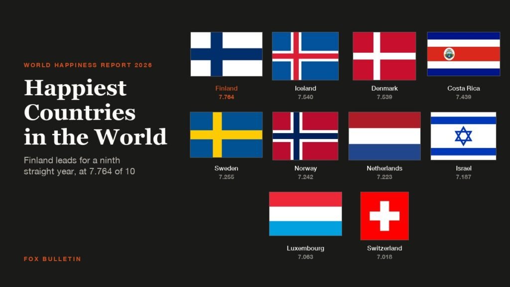
Finland tops the World Happiness Report 2026 at 7.764, its ninth consecutive year at number one. Iceland edges Denmark by 0.001 points, Costa Rica reaches fourth, and no English-speaking country makes the top 10 for a second straight year.

Best Oversized T-Shirts for Women: 7 Compared
The best oversized t-shirts for women differ from each other in three places: what the fabric is made of, where the shoulder seam sits and how the hem is shaped. Those three…

Best Oversized T-Shirts for Men: 7 Picks Compared
The best oversized t-shirts for men are not simply large t-shirts. The shape comes from where the shoulder seam sits and how much the fabric weighs, which is why a Pro Club…